What am I going to learn in Geography?
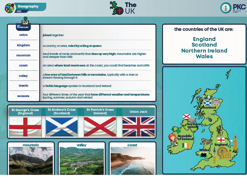
Year 1 - The UK
The word ‘union’ means joined together. The United Kingdom is a union of four countries. The four countries in the United Kingdom are: England, Northern Ireland, Scotland and Wales. Scotland is a country in the United Kingdom. Scotland is located to the north of England. The Scottish flag is called the St Andrew’s flag and is blue with a white cross. Wales is one of the countries in the United Kingdom. There are mountains and valleys in Wales. Cardiff is the capital of Wales. Northern Ireland is one of the countries in the United Kingdom. The capital city of Northern Ireland is Belfast. The giants causeway is made of rocks.
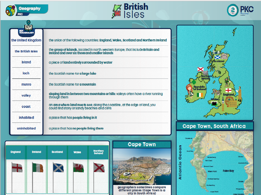
Year 2 - British Isles
An island is a body of land entirely surrounded by water. The main islands of the British Isles are Britain and Ireland. England is one country in the British Isles. Scotland is a country in the British Isles. Scotland is located to the north of England. The mainland of Scotland is part of the island of Great Britain. Wales is one of the countries in the British Isles. Wales is part of the island of Britain. In the past, many ships were wrecked off the western coast of Wales
Ireland is one of the islands in the British Isles. There are two countries located on the island of Ireland, Northern Ireland and the Republic of Ireland. The Giant’s Causeway is located in Northern Ireland and has interesting shaped rocks.
Year 3 - Rivers and the Water Cycle
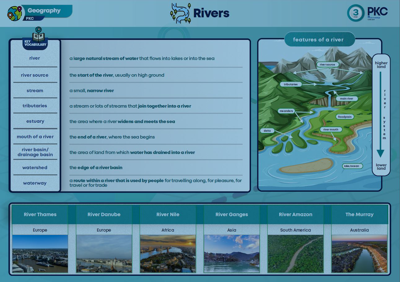
Throughout time people have lived by rivers and used them for food and transport. Every river begins as a stream and starts at a ‘source’, and ends with an estuary. When streams merge together they form a river. The River Thames is the longest river in England. Many rivers in England flow through more than one county, but many rivers in Europe will flow through more than one country. The River Danube flows through ten European countries.
There are two main rivers flowing through Africa- the Nile and the Niger. Both rivers flow through more than one country. Both rivers are important for trade and travel.
There are five important rivers in Asia- The Yellow, the Yangtze, the Ob, the Ganges and the Indus. The Yellow and the Yangtze flow through China. Ancient Indian civilisation began along the river Indus.
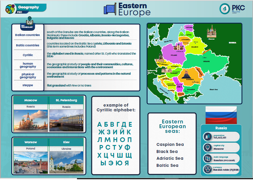
Year 4 - Eastern Europe
Eastern Europe covers a wide area, with many countries, peoples, cities and rivers. Some Eastern European countries are grouped into Balkan or Baltic Countries. Eastern European countries have different languages. It has a continental climate. Balkan countries are closer to the equator so are slightly warmer. Baltic countries are further north and so are colder.
There are some very long rivers in Eastern Europe, including the Danube and the Volga. The Caucasus Mountains form a boundary between Europe and Asia and contain Mount Elbrus, Europe’s tallest mountain. The Pinsk Marshes are one of Europe’s largest wetland areas.
Russia and Ukraine share a border in Eastern Europe. Russia invaded the Ukraine in 2022 to take control of land. The war that followed the invasion caused many people to leave their homes to seek safety.
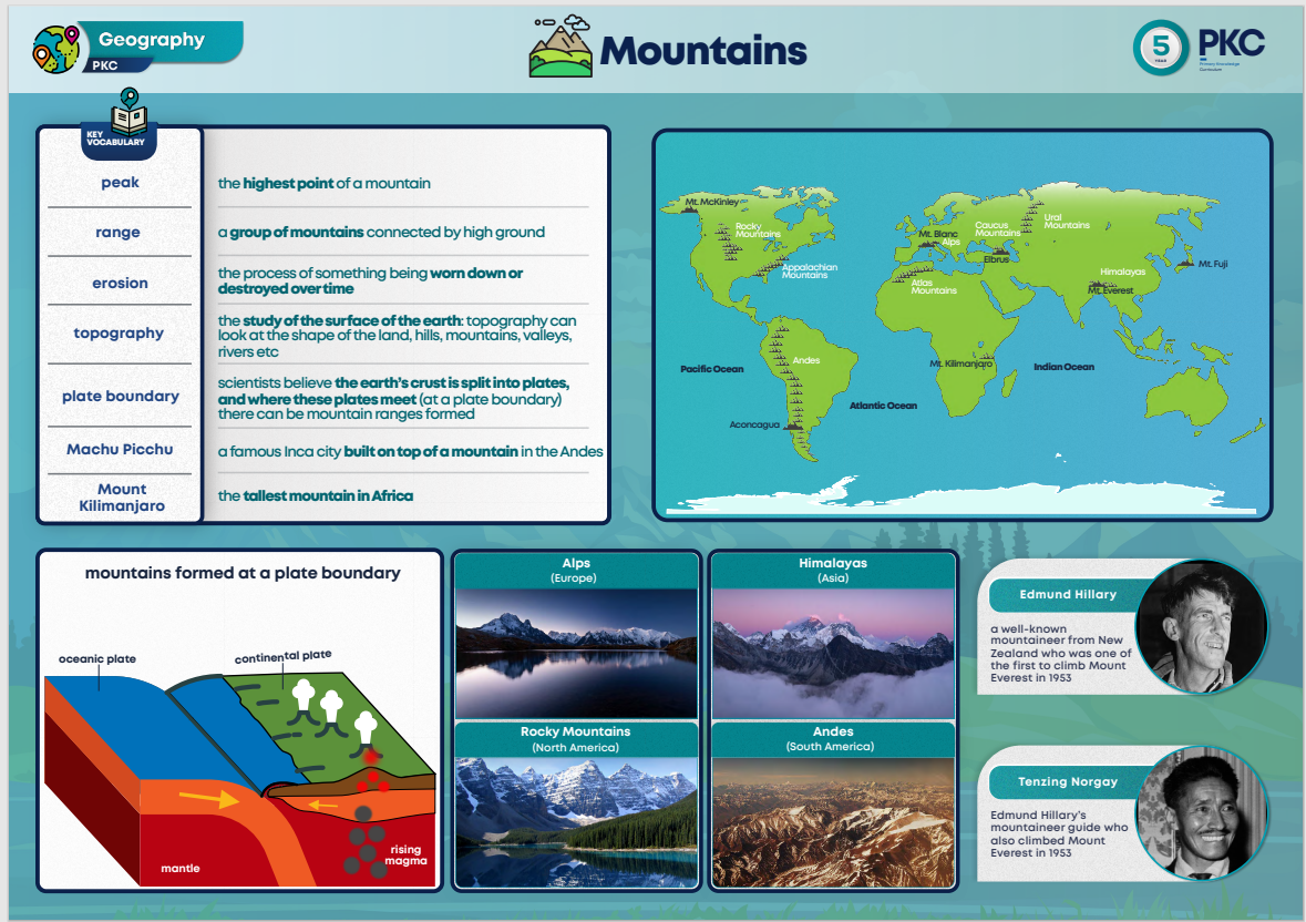
 Year 5 - Mountains
A mountain is a large landform that rises above surrounding land. Mountains are often found in groups called mountain ranges. There are many mountains around the world including the Andes, Mount Everest and the Rocky Mountains. The Alps are a mountain range in Europe. Mont Blanc is the highest mountain in the Alps. Otzi was a 5000 year old man found in the Alps.
Mount Everest, in the Himalayas is the world’s tallest mountain (above sea level). The Himalaya’s are ‘young’ mountains. They are approximately 50 million years old. In 1953, Edmund Hillary and Tenzing Norgay were the first people to climb to the peak of Mount Everest.
There are three main mountain ranges in North and South America: The Andes in South America, and the Rockies and Appalachians in North America. The Andes are the world’s longest mountain range and were home to the Inca civilization. The Appalachians were once as high as the Alps, but are so ancient they have weathered down.
Mount Kilimanjaro is not part of a mountain range. The Ethiopian Highlands are full of incredible wildlife, as well as geological features like lava lakes. The Ethiopian highlands lead into the Great Rift Valley, where it is believed that humanity first evolved.
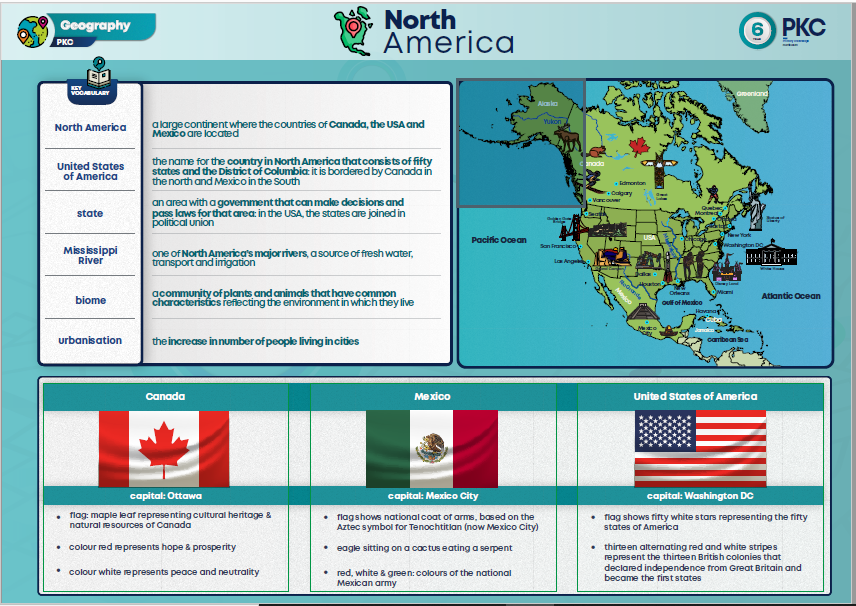
Year 6 - North America
North America is a continent, many countries are located within it. Some of the larger countries in North America include Canada, the USA and Mexico. Some of the smaller countries in North America include Jamaica, Barbados, and Haiti (or other examples). Due to its size, North America has several different biomes located within it. Arctic Tundra has a layer of frozen soil that prevents trees from growing. Near the equator, tropical forest is hot and wet, trees grow tall and close together.
North America’s rivers are an important source of fresh water, act as transport routes and are used for irrigation. North America’s rivers have been affected by human actions. The Panama Canal is a human-made waterway connecting the Atlantic and Pacific Oceans. Increasing population in urban areas can cause pressure on housing, house prices rise and affordable housing can become scarce. Increasing population in urban areas can put pressure on the environment, more pollution is created, more water is required, land is needed for new buildings. Solutions can include careful city planning, planting trees and managing green spaces, creating affordable housing.